
 The state of VA is shaped roughly like a right angle triangle. At the very tippy top of the state is Leesburg, which, technically, is in the northernmost part of the state. Leesburg is at a crossroads of sorts, near the W. VA line 34 miles south of Harper's Ferry, MD and 38 miles east of Winchester, VA, which is also very near a state border. In spite of its location, Leesburg & Winchester are not what people are talking about when they are talking about Northern VA, or NoVA. The metro DC part of Northern VA stretches from the Dulles area (Sterling, Herndon, & Reston), which is roughly 15 miles south of Leesburg and 30 miles northeast of DC, so still rather far out for the metro area, to Fredericksburg, VA, 58 miles south of Washington, DC. Fredericksburg is really an outlying suburb, as you can see from the map, and the fact that it's 58 miles from DC. On the map, you can see where Arlington & Alexandria, close-in VA suburbs, look quite far away from Fredericksburg and Charlottesville. In fact, though Fredericksburg is considered an outlying part of NoVA, it is only 57 miles north of Richmond, the state's capitol.
Ok, so we've covered the tippy top part of the state down to R
 ichmond, which is in central VA. No mountains, no sea. Richmond lies on the fall line, the place where rivers run over rocks and cities spring up. The fall line is the dividing line between the soft, sandy soil of the Coastal Plain to the east and the mountainous areas to the west. So though Richmond is not technically in the middle of the state, it also represents a crossroads of sorts, a geographical one.
At the very bottom corner of the state lies Hampton Roads. Just as NoVA is neighbors
 with Maryland, HR is neighbors with mostly rural and coastal parts of North Carolina and the Eastern Shore. The very bottom of Virginia Beach & Chesapeake butts up with North Carolina. From the Peninsula, you can go to small coastal NC cities like Elizabeth City and small inland country-setting towns like Ahoskie in less than 2 hours.
Culinary sidenote: I haven't been to Ahoskie, but I have family members who take jaunts to get the very delicious and unique N
 C country sausage sold there. For many years I didn't like it, but they finally happened upon a less salty brand that I love. When I was on the New Stories tour, we had dinner at the Piedmont. I had sausage and polenta, and that's when it clicked for me - I could tell the sausage was NC sausage by its texture, but that was the first time I understood how good it could be when done well, with good cuts of meat, herbs, and not oversalted. Good stuff!
Hampton Roads is cut through and surrounded by water, and is as far south
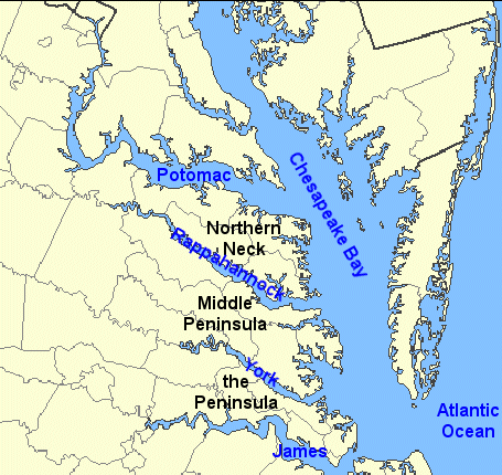
 and as far east as one can go in the state (except for the Eastern Shore). Richmond is one hour to the west - remember, this is where the land changes from coastal to the fall line and gradually becomes mountainous. The James is a tiny sliver in Richmond, as it flows over rocks and downstream into Newport News and into the Hampton Roads Harbor, the Chesapeake Bay and the Atlantic Ocean. Instead of sitting on huge rocks in Richmond watching the James river swirl around you, you are standing next to the James, or Hampton Roads, or the Chesapeake Bay, or the Atlantic, watching pleasure boaters and huge container ships pass and huge ships standing still at the shipyards.
So Richmond is one hour to the northwest. At this crossroads, you can take
 95 north for 2 more hours to DC, or stay on 64 West for another hour into Charlottesville. At this point, you are really getting into mountain territory. You can see mountains in the near distance, and within 30 minutes to another hour, can be on the top of one in Wintergreen. I-81 runs along the western side of the state from the mountainous north, near W.VA & MD, to the mountainous south - Appalachia, near Tennessee.
Since the state is shaped like a triangle, it gets wider as one travels from north to south. So basically, it would take me longer to get from Hampton Roads in the far southeast to the farthest southwestern part of the state than it would to get to NYC. Both trips would take me to an entirely different world. Appalachia is as different from coastal VA as are the huge Gothic structures in Manhattan (love that architecture). I saw a contestant on some
 reality show from Coeburn, VA. I looked it up and found that it was in the far southwestern part of the state. Slightly farther, almost as far west as you can go is Wheeler, VA, which is 487 mi – about 8 hours 5 mins from Hampton, VA. New York City is 402 mi – about 6 hours 57 mins (up to 8 hours 20 mins in traffic). In other words, the bottom of the triangle is as long as it looks, and the middle is pretty wide too. When I went to the VA Festival of the Book at UVA, a bookstore owner asked me where I was from. I told him, and he said, "Oh, you're from out east," and winked at me.
So if you're looking for mountains, check out Roanoake, Nelson County, Harrisonburg, or any other city along I-81. Or come see us out at the coast!

1 comment:
Did you see this article about real estate bloggers?
http://www.nytimes.com/2008/10/31/greathomesanddestinations/31bloggers.html?_r=1&oref=slogin
Post a Comment